Forecasters are monitoring the potential first tropical cyclone of the 2026 Atlantic hurricane season, saying it could develop into a fully formed storm by Wednesday, they said.
The National Hurricane Center issued a preliminary weather advisory for the system, currently a tropical disturbance called Potential Tropical Cyclone One, on Tuesday morning.
It came as record rainfall and life-threatening flash floods continued to drench parts of the South, where communities braced for up to 7 or 8 inches of additional rain throughout the rest of the week.
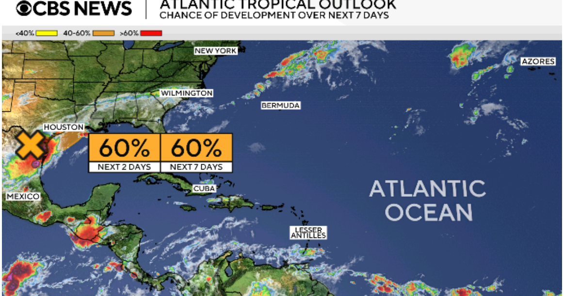
Potential Tropical Cyclone One was located in the western Gulf early Tuesday, between Corpus Christi, Texas, and Lake Charles, Louisiana, according to the National Hurricane Center. It was traveling northeastward with winds of 30 mph, below the 39-mph threshold necessary to designate it a tropical storm.
The potential tropical cyclone also lacked a well-defined center as of the most recent update, although forecasters said the system will likely intensify and have tropical storm-force winds on Wednesday. Whether that happens or not, the National Hurricane Center emphasized the system could bring serious hazards to coastal sections of northeastern Texas and southwestern Louisiana, as well as parts of Alabama and Mississippi. Far-western portions of the Florida Panhandle could be affected, too.
Dangerous rainfall and flash flooding were the primary threats associated with the potential cyclone, forecasters said, adding that “significant river flooding” was possible and, in some spots, “prolonged rainfall may extend the flood threat into the weekend.”
A tropical storm watch was issued Tuesday for a stretch of the northwestern Gulf Coast, from Sargent, Texas, to Morgan City, Louisiana, which means tropical storm conditions could take shape there in the next 24 to 36 hours.
Several major cities, including Dallas, Houston, San Antonio and New Orleans, could experience ongoing spells of excessive rainfall, especially over the next 48 hours or so, forecasts showed. Various flood watches and warnings were in effect for more than 40 million people across the region, as meteorologists predicted some areas could see rainfall rates of 2 to 4 inches per hour, or higher.
Multiple places still vulnerable to flooding before the week’s end have already been battered by heavy rain. National Weather Service offices in Austin, San Antonio and Shreveport, Louisiana, each reported record rainfall in their cities on Monday, with the latter two receiving more rain in a single day than either had seen since the late 19th century.
Texas’ capital city broke a daily rainfall record set in 1964, according to the National Weather Service.
contributed to this report.