Cyclone Maila, which had intensified into a category five storm, has weakened as it continues its slow progress across the Solomon Sea.
After being pegged as one of the strongest of the season, Cyclone Maila weakened over the past 24 hours, initially getting downgraded to category four, before being downgraded again to category three on Friday.
The storm is expected to make landfall along the coast in Australia’s Queensland early next week.
Here’s the latest on Cyclone Maila
According to the latest bulletin by Australia’s Bureau of Meteorology (BoM), Cyclone Maila was positioned between Papua New Guinea and the Solomon Islands, and was moving southwestwards at a sluggish pace of 8 kilometres per hour.
As of 0000 hrs UTC on Friday, Cylone Maila had a maximum 10-minute wind speed of 140 kmph, with a maximum 3-second wind gust of 195 kmph.
Why is Cyclone Maila weakening?
The BOM’s latest technical bulletin notes that environmental conditions are currently unfavourable for the storm’s development, contributing to the storm’s gradual weakening.
The system’s intensity has been sapped by two primary factors: persistent easterly deep-layer wind shear—measured at approximately 20 to 25 knots—and a significant reduction in local sea surface temperatures. Because the cyclone has remained slow-moving over the past several days, it has triggered turbulent oceanic upwelling, which has cooled local waters to between 24 and 26 degrees Celsius, the bulletin said.
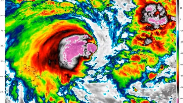
Consequently, the storm’s satellite signature has degraded considerably over the past 18 hours, marked by the loss of the eye and a reduction in central convection. The central pressure, as of 0000 UTC on Friday, was recorded at 966 hPa.
Where is Cyclone Maila heading?
While the cyclone remains slow-moving, meteorological models suggest a west-southwestward motion should become established over the next 24 hours. According to the BoM’s latest analysis, the most likely track will see Maila drift southwest and pass close to southeastern Papua New Guinea.
After moving past Papua New Guinea, the system is expected to continue on a general west to west-southwest trajectory towards Australia’s Cape York Peninsula. However, forecasters note there is still considerable spread in the long-term track and the forward speed of the storm.
Impacts to the Queensland coast are possible from as early as Monday through to mid-next week, most likely around the Cape York Peninsula.
Alternatively, some recent model guidance indicates Maila could track further west rather than southwest. In this scenario, interactions with the topography of southeastern Papua New Guinea could cause the system to weaken rapidly over the weekend and dissipate into a trough in the Coral Sea early next week.
Regional impacts and warnings
Currently situated over the Solomon Sea, an unfavourable environment has initiated a gradual weakening of the storm. Persistent easterly wind shear and a reduction in local sea surface temperatures—caused by oceanic upwelling from the storm’s slow movement—have degraded Maila’s satellite signature, resulting in the loss of its eye and a shrinking of central convection.
As Maila moves southwest, southeastern Papua New Guinea is expected to face the storm’s immediate impacts over the weekend. Forecasters warn that the region could experience a prolonged period of destructive winds as the system passes close by.
The cyclone, however, is expected to interact negatively with the Papua New Guinea landmass, and is likely to see a further reduction to its strength. If the storm tracks directly into the region’s topography, it could weaken rapidly and fail to reach the Australian coast as a cyclone.
Conversely, a handful of models suggest the storm could even weaken in-situ over the Solomon Sea before advancing much further.